Time Walk
Where a Meadow Used to Be


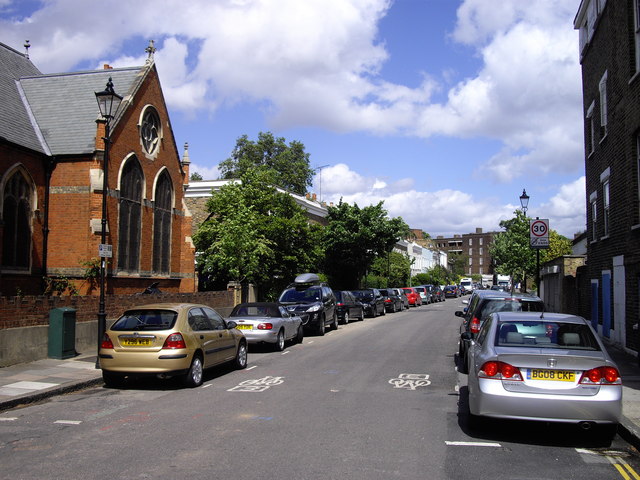
This was once wet meadow ground, not a street at all. Today Meadow Road is a quiet mixed residential run on the eastern edge of Vauxhall, with the red brick tower of the Cavalry Church visible at its junction with Fentiman Road. Houses on its northern stretch are protected from unauthorised alteration by a council order.
Underneath the terraces lies a much older boundary line. For much of the nineteenth century this road marked the edge of a private copyhold estate, and before that, land here was recorded as riverside meadow in the early 17th century. That older layer is where the street's name comes from.
Name Origin
Caron House or Prince's Mead?
Two accounts give slightly different roots for the name. One source holds that Meadow Road is named after meadows once attached to Caron House. The Survey of London instead identifies the meadow as Prince's Meadows, first documented in Norden's early 17th-century Survey of Kennington.
Norden's survey listed a 25-acre field called Prince's Mead, let at that time to a tenant named William Page. By 1660, during the Commonwealth period, houses and wharves had been built along the river bank beside these meadows. Whichever meadow the name preserves, it points back to open, low-lying ground near the Thames long before any road ran across it.
History
The Fentiman Boundary
For much of its history, Meadow Road was a property line, not a destination. In 1806 John Fentiman the elder purchased a copyhold estate whose boundary Meadow Road formed, together with Fentiman Road, Clapham Road and Wilkinson Street. That estate shrank over the following decades. When John William Fentiman was admitted to it in 1857, it covered only the land between Meadow Road, Fentiman Road, Palfrey Place and Dorset Road.
The street's modern character was shaped much later by war and by planning policy.
A V1 flying bomb struck the site of Stoddart House on Meadow Road during the Second World War.
Recent Times
Landmark at the Eastern Edge
Meadow Road now sits at the outer edge of a protected area. The Vauxhall Conservation Area's eastern boundary extends as far as Kennington Oval and Meadow Road, and at the junction with Fentiman Road the Cavalry Church is described as an attractive landmark marking that boundary.
In 2016 Lambeth Council considered Meadow Road for inclusion in an extension to the conservation area, judging its properties to belong with Vauxhall rather than with the neighbouring Clapham Park and Northbourne Road area. The street also falls within the separate St. Mark's Conservation Area. Nos. 6–42 remain subject to an Article 4 Direction removing permitted development rights, a measure meant to keep those houses from being altered without permission.
Today
A Quiet Boundary Still
Meadow Road remains, as it has long been, an edge rather than a centre. It still marks the boundary of the Vauxhall Conservation Area, with the Cavalry Church standing at its corner with Fentiman Road as the clearest sign of where that boundary falls. The meadows that gave the street its name are long gone, but the idea of an edge, a copyhold line, a conservation boundary, a bomb site, has kept returning to this short stretch of road.
On the Map
Meadow Road Then & Now
Frequently Asked Questions
Why is it called Meadow Road?
One account says it is named after meadows once attached to Caron House. The Survey of London instead links the name to Prince's Meadows, a 25-acre field recorded in Norden's early 17th-century Survey of Kennington.
What is Meadow Road known for?
It is known for marking the eastern edge of the Vauxhall Conservation Area, for the Cavalry Church at its junction with Fentiman Road, and for having once bordered a Georgian copyhold estate owned by the Fentiman family.
Was Meadow Road damaged during the Second World War?
Yes. A V1 flying bomb struck the site of Stoddart House on Meadow Road during the war, according to a Layers of London record of the incident.