Time Walk
Walking Above the Effra


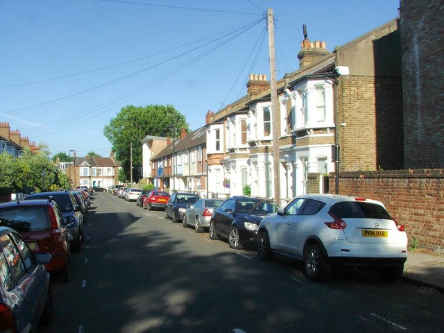
A river you cannot see still runs beneath this road. The River Effra flows in a culvert here, carrying the old stream into the sewers beneath nearby streets. Walking along today you pass Victorian terraces, set-back villas and the remains of a former synagogue.
Before any of it, this was open common. The road was cut across Rush Common and Norwood Common in 1810 to open farmland for building. Front gardens and grass verges along the road survive from that older, unbuilt land — which is where the Name Origin lies.
Name Origin
From Heathrow to Effra
The name probably comes from a lost estate, not a bend in the land. "Effra" appears to be a corruption of "Heathrow", the name of a farm or estate recorded here in medieval documents. The road itself ran directly in front of Effra Farm, between Coldharbour Lane and Brixton Water Lane.
The river took the same name, or gave it — the sources used here do not resolve which came first, only that both forms trace back to "Heathrow". The River Effra flows from near Westow Hill, and its culverted course now carries sewers under Croxted Road, Brixton Road and others nearby. The manor itself was later known as the manor of Heathrow, Milkwood and Wickwood.
History
Enclosure, Restriction, and the Rise of Rush Common
Effra Road exists because common land was carved up. In 1810 the Lambeth Manor Inclosure Commissioners formed the road to give access to new inclosures on Rush Common and Norwood Common, alongside the parallel St Matthew's Road. Rush Common itself lay in the triangle bounded by Brixton Hill, Effra Road, and a line running south-west from the Effra Road–Water Lane junction, with a narrow spur up the east side of Brixton Hill.
An Act of 1806 had already set the terms: no buildings were to rise "above the Surface of the Earth" within 150 feet of the Brixton turnpike road, or within 200 feet of the old field boundaries that framed the common. An amending Act of 1821 made Effra Road and St Matthew's Road parish highways and relaxed the restriction only to permit a church, burial ground and parsonage — which became St Matthew's, begun in 1822 on a triangular site where Brixton Rise meets Effra Road. Through the 1820s, detached houses of varying size were built along the west side of the road, each set well back from the frontage to satisfy the inclosure rules.
East of the road lay Effra Farm, the roughly 70-acre estate Robert Stone had assembled in four purchases between 1791 and 1806. Stone died in 1820, and his heirs divided and sold the land between 1824 and 1826. Further along, in 1840, Brixton Unitarian Christian Church took a long lease of a site on the east side of the road; the chapel it built there stood until it was destroyed by enemy action in 1940. In 1921 Brixton Synagogue was founded here.
Culture
Chapels, a Synagogue, and a Prime Minister's Pub
Three places of worship once stood along this stretch within a century of each other: St Matthew's in 1820, the Unitarian chapel in 1840, and the synagogue last, in 1921.
A more irreverent landmark stood at the Brixton Water Lane corner: a pub named for Prime Minister George Canning (1770-1827). It kept his name until the late 1990s, when it became the Hobgoblin, and then the Hootananny in 2008. More recently, when Transport for London consulted on the Cross River Tram, most respondents preferred a route running through Effra Road in Brixton town centre.
People
Comedians on the Common
Music hall performers lived quietly among the villas. William Govett — known on stage as Will Poluski, one half of the Poluski Brothers — was recorded living at 2 Effra Road in 1911. The Poluski Brothers had begun as circus performers in the 1870s, billed as "eccentric comedians and acrobatic marvels", and became one of the most popular acts of the pre-First World War music hall stage. Poluski died in 1924.
"eccentric comedians and acrobatic marvels"Billing for the Poluski Brothers, via Layers of London
A few doors along, at No. 83, lived Stewart and Delhi, whose main address was given here between 1913 and 1915. Hal Stewart, born John Horace Squires in Lincolnshire in 1887, performed with Delhi — born Pansy Bannerjee in Kashmir in 1892 — in what was billed as a "unique fencing, vocal and dancing act". Stewart died in 1957, Delhi in 1974.
Recent Times
A Conserved Corridor
The road's older character is now formally protected. Large parts of Effra Road were included in the Brixton Conservation Area when it was first designated in November 1980, and the area has since been extended three times. The road is also designated an Archaeological Priority Area, in recognition of what may lie beneath it.
The old inclosure rules have left a visible trace. Rush Common's legislation against "erections or buildings above the surface of the earth" still governs the open spaces and front gardens running along Effra Road.
Today
What Still Stands
A handful of buildings carry the road's layered past. Raleigh House, built early in the 1800s, is a plain early survival from Rush Common. Nos. 91 and 93 are also early survivals. No. 47 is a symmetrical 1840s villa.
The only trace of the London Transport ticket printing works that once stood on Effra Road is a single inter-war concrete lamp column, still standing on the verge.
At the gates of St Matthew's Peace Gardens, 19th-century cast-iron parliamentary boundary markers still stand. Beneath it all, unseen, the River Effra that may have given the road its name keeps flowing through its culvert.
On the Map
Effra Road Then & Now
Frequently Asked Questions
Why is it called Effra Road?
The name probably derives from "Heathrow", a farm or estate recorded here in medieval documents, according to the Brixton Society's account of local street names. The River Effra, which flows beneath the road in a culvert, likely shares the same root.
What is Effra Road known for?
It is known for being laid out across common land in 1810 under strict building restrictions, for the Brixton Synagogue founded there in 1921, and for early 20th-century music hall performers who lived along it.
What happened to the River Effra?
It was culverted and now runs as a sewer beneath Effra Road and several neighbouring streets, including Croxted Road, Dulwich Road, Dalberg Road and Brixton Road.