Time Walk
From a Lane to a Well to a Suburban Street


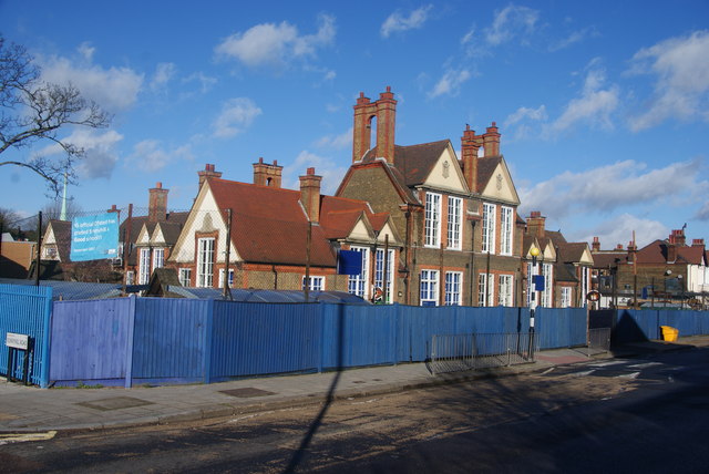
This was once a dog-leg lane leading to a spring said to have healing waters. Today small shops, pairs of Victorian cottages and a red-brick church line the street. Walkers notice the castellated turret at the Streatham High Road corner and a fish and chip shop with its original tiled front.
Beneath the shopfronts and porches lies an older route to mineral wells, long since built over. The name the street carries now only arrived in 1894, when two older lanes were joined and renamed.
Name Origin
Two Lanes Become One
The name is younger than the road itself. The western section running from Streatham High Road to the Leigham Arms, together with Wells Road, began as a dog-leg lane known as Well Lane, recorded in 1659 as the route to medicinal mineral wells at Valley Road. By 1867 a short spur running east from the pub had appeared on the Ordnance Survey map as Leigham Lane, lined with pairs of semi-detached cottages.
By 1894 the western spur of Well Lane and Leigham Lane had merged and were given the single name Sunnyhill Road, while the remaining stretch of the old lane was renamed Wells Road. The sources consulted here record this merger and its date but do not explain the choice of the name "Sunnyhill" itself.
History
Cottages, a Grammar School and a Church
A tavern had stood at the corner since at least 1861, and institutions followed quickly once the lane filled in. The Streatham National Infant School was built in 1867, the same year Blackwood Hall replaced an earlier chapel on the street. No. 122 housed the Streatham Grammar School, founded in 1880, and All Saints' Church went up in 1896. A further board school, Sunnyhill Road School, opened in 1900.
By the 1890s the street's commercial life was fading as rail and road improvements and the growth of Streatham High Road drew trade away. The 1897 Ordnance Survey map shows the area largely built out, though open fields still lay to the east, giving the road a bucolic character. Even as Streatham around it became a prosperous middle-class suburb, Sunnyhill Road itself remained working class into the early twentieth century, and the Valley Road dairy nearby was a fixture of daily life.
The Leigham Arms is only documented from 1861 and appears on the 1867 OS map as a "beer house", but the council's appraisal suggests an inn may have stood at that corner since the earlier spa period, when travellers came for the wells nearby.
"beer house"Lambeth Council, Sunnyhill Road Conservation Area Character Appraisal, 2017
Recent Times
Drawing New Lines Around Old Cottages
Conservation status has reshaped the street's boundaries more than once. The Sunnyhill Road Conservation Area, designated in 1973 and extended in 1982, lost part of its ground in 1999 to the neighbouring Streatham High Road and Streatham Hill Conservation Area. Lambeth's conservation area maps now list it as Area 15, sitting next to the Leigham Court Estate and Streatham High Road/Streatham Hill areas.
The surviving mid-19th century "Wells cottages" at Nos. 60-78, 84-86 and 88-90 were added to Lambeth's Local Heritage List in January 2021.
Today
Shopfronts at the High Road End
Small shops still line the stretch nearest Streatham High Road. Nos. 2a to 22 are a row of modest shops, mostly refronted in the late twentieth century, though No. 20 keeps its original frontage as a fish and chip shop, with a brown glazed tile stallriser and decorative metal vent still in place. No. 16 has a newly refurbished front nearby.
At the corner stands No. 1, a free-standing building of 1909 in red brick with a decorative gable, built around the same time as the turreted parade of shops at Nos. 73a-89 Streatham High Road next door. That octagonal castellated turret still marks the corner where Streatham High Road meets Sunnyhill Road — a Victorian flourish standing over a street whose own name is barely older than it is.
On the Map
Sunnyhill Road Then & Now
Frequently Asked Questions
Why is it called Sunnyhill Road?
By 1894 two older lanes — the western spur of Well Lane and Leigham Lane — were merged and given the single name Sunnyhill Road. The sources used here record the date of the merger but not why this particular name was chosen.
What is Sunnyhill Road known for?
Its mid-19th century "Wells cottages" at Nos. 60-78, 84-86 and 88-90, now on Lambeth's Local Heritage List, and its origins as a lane leading to medicinal mineral wells recorded as early as 1659.
How old is the Leigham Arms pub?
It is documented from 1861 and appears on the 1867 Ordnance Survey map, though an inn may have stood at that corner earlier still, from the days when travellers visited the nearby wells.