Time Walk
The Road That Would Not Be Tamed


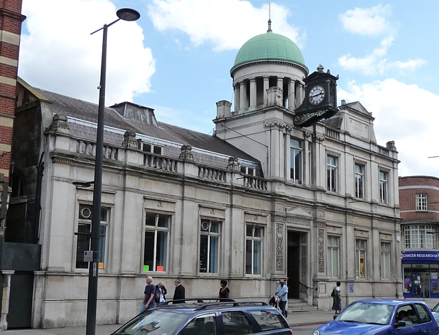
A Roman road to the Sussex coast still decides where this street runs, two thousand years on. Today it's fast traffic and long parades of shops, including the ornate Triangle parade built in the 1880s and 90s — later voted Britain's worst street for traffic.
Beneath the shopfronts lies an older story: a small Roman fort may once have guarded the road at St Leonard's Church. That road, and the hamlet beside it, gave the street its name.
Name Origin
Strat and Ham: A Hamlet on the Street
The name comes from the Saxon "Strat," meaning street, and "Ham," meaning settlement — a hamlet beside the street. The street in question was a Roman road running south from London towards the coast, sometimes confused with Stane Street, which diverged from the main London–Chichester road near Kennington and ran on through Streatham towards Brighton.
The earliest written form appears in Domesday Book in 1086, where the manor is recorded as Estreham; by 1175 it had become Stratham. An earlier document, the Chertsey Register, records a grant of land in 675 by Frithwald, acting for King Wulfhere of Mercia, to seven farmsteads described as "apud Toting cum Stret" — at Tooting, with the street.
"apud Toting cum Stret"The Chertsey Register, 675
History
From Fort to Turnpike to Tramline
Roman masonry and a ditch found at St Leonard's suggest a small military station once stood on the site, enclosing two or three acres behind an earthwork. Pre-Christian burials turned up when the church was rebuilt in the 19th century, showing the ground had been used for burial for over 2,000 years. After the Conquest the manor passed to Richard de Tonbridge, and by 1086 Domesday valued it at 60 shillings with around fifty inhabitants. A medieval village grew up around St Leonard's, at the junction with Mitcham Lane, and the parish registers, begun in 1538, recorded plague deaths and, it was said, victims of highwaymen on Streatham Common.
Medicinal springs discovered in 1659 drew fashionable visitors; by the early 18th century the Common and the High Street were, in one description, "fashionable promenades where all the leaders of society might be met," and spring water was still pumped and sold until the outbreak of the Second World War. In 1780 the road became a turnpike on the route to Brighton, the ancestor of today's A23. The population exploded from 12,000 in 1871 to 71,000 by 1901 as trams arrived, reaching the Tate Library terminus in 1904 and being electrified the same year. A Zeppelin bomb destroyed the house called Arborfield on the corner of Sternhold Avenue overnight on 23–24 September 1916, and a V1 flying bomb badly damaged the corner of Wyatt Park Road on 24 June 1944.
The usual dose of Streatham's medicinal spring water was about three cups — said to equal nine cups of Epsom salts water.
Culture
Cinemas, a Dance Hall, and a Department Store
Three cinemas once stood along the High Road. The Astoria opened in June 1930 with an Egyptian-themed interior of red, green and gold and bas-relief walls; Odeon took it over in 1939 and remodelled it in 1961, stripping out most of the original interior. The Regal, opened in 1938, later became the ABC and was listed Grade II in 1998. Pratts department store traded nearby until 1990. At No. 177, a shopfront and interior from around 1900, built for the grocer David Greig, was listed Grade II in 2000 and largely retains its original fittings.
People
A Sugar Baron, a Toxicologist, and a Forgotten Artist
Streatham Library at No. 63 opened in 1890, funded by a £5,000 gift from Henry Tate, the sugar refiner who had patented sugar-cube manufacture in 1872 and built a new refinery in Liverpool that year. Tate was made a baronet in 1898, the year before his death, and lived nearby at Park Hill by Streatham Common.
At No. 107, the Wetherspoons pub takes its name from Joseph Holland Tringham, a Victorian artist and illustrator who moved to Streatham in 1891 and exhibited at the Royal Academy; he died in 1908 at 45, in the Isle of Man, having been certified insane. Thomas Stevenson, the Home Office's forensic toxicologist, died at his home on the High Road that same year, 1908, and was buried at West Norwood Cemetery.
George Pratt arrived in Streatham at 13 as a drapery apprentice in the 1850s, when the village held around 7,000 people; within eleven years he had bought out his employer's business and built the department store that bore his name until it was sold in 1919.
Recent Times
Infamy, Investment, and a Redrawn Boundary
In September 2002 a BBC and CABE poll named Streatham High Road the "Worst Street in Britain," reflecting the dominance of through traffic over the parades of shops. On 2 February 2020 Sudesh Amman stabbed two people on the High Road in what police described as a terrorist incident; he was chased along the street and shot dead by police outside a Boots chemist's. Streatham station gained step-free lifts to both platforms in autumn 2023. In January 2024 the part of the conservation area south of the railway was removed from protection, Lambeth Council recording that redevelopment had radically changed its character since the area was first designated.
Today
Still the Road South
The High Road remains designated the A23, carrying traffic south much as its Roman predecessor did. Streatham Common lies along it, and the street is still described as a busy arterial road of fast-moving traffic and shop parades. It sits roughly a mile west of the centre of West Norwood.
On the Map
Streatham High Road Then & Now
Frequently Asked Questions
Why is it called Streatham High Road?
"Streatham" comes from the Saxon "Strat" (street) and "Ham" (settlement) — a hamlet on the Roman road that ran south from London towards the Sussex coast. The name was recorded as Estreham in Domesday Book in 1086 and as Stratham by 1175.
What is Streatham High Road known for?
It is known for following an ancient Roman route, for its Victorian shopping parades and cinemas, for Streatham Library (funded by Henry Tate), and, less happily, for being voted "Worst Street in Britain" in a 2002 poll over its traffic.
Is there evidence of Roman activity on the street?
Yes. Roman masonry, coins and a ditch were found at the site of St Leonard's Church, where a small fort may once have stood, and the road itself likely follows a Roman route towards the south coast.