Time Walk
A Street That Stopped Going Anywhere

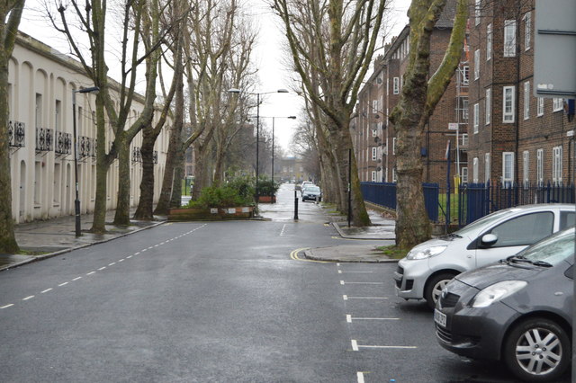
This street once ran through to Vassall Road; today it simply stops at a patch of grass. Walking it now means passing close-set terraces with iron railings and small front gardens, giving the road a tight, enclosed feel. Look south and the view is closed off neatly by an attractive terrace on Cancell Road.
The truncation dates only to the 1970s, when rehabilitation of the area reshaped the street's southern end into open space rather than a junction. That change, more than anything built here, is what makes a short walk down Russell Grove worth taking before turning to what its name might mean.
Name Origin
A Name Without an Explanation
The sources used here do not explain why this street is called Russell Grove. No lease, listing entry or appraisal consulted for this page gives a reason for the name, so none can be offered here.
History
Early Victorian Terraces, Mid-Century Rebuilding
The oldest houses on Russell Grove are early-to-mid Victorian. Nos. 6-12 form a symmetrical terrace with a stone base and slightly projecting ends, first listed Grade II in 1981.
Further along, Nos. 13-20 form four pairs of matching houses, unusual for their red brick set against the plainer brick around them. Nos. 21-22 form another matching pair, and Nos. 23 and 24 are smaller individual houses, one with a banded front, the other with a plain roof. All are recorded as holding group value with their neighbours.
The 1970s brought the street's biggest change. Rehabilitation of the wider area cut Russell Grove off from its old connection to Vassall Road, and infill building added two public spaces and a short terrace of shops and flats in its place.
Recent Times
Added to the Local List
Recognition of the street's houses has come in stages. Nos. 6-12 gained national listing in 1981, but it was not until January 2021 that the remaining terraces at Nos. 13-24 were added to Lambeth's Local Heritage List, for their group value with their older neighbours.
Today
A Green Where a Road Once Ran
Russell Grove today reads as a small, intimate pocket of the Vassall Road area. The street's southern end opens onto a landscaped square with mature trees, with views to the rear of houses on Vassall Road. From this open space, the spire of St John the Divine rises above the rooftops.
A second, smaller public space on Russell Grove is an informal paved garden, added as part of the same 1970s rebuilding that closed the street's old route through to Vassall Road.
On the Map
Russell Grove Then & Now
Frequently Asked Questions
Why is it called Russell Grove?
The sources used for this page do not explain the origin of the name Russell Grove.
What is Russell Grove known for?
Its Grade II listed early-Victorian terrace at Nos. 6-12, and for having lost its original through-route to Vassall Road in the 1970s, when its southern end became a small landscaped green.
Can you still walk through from Russell Grove to Vassall Road?
No. The street originally connected to Vassall Road, but after 1970s rehabilitation of the area it now ends in a small communal green rather than continuing through.