Time Walk
A junction that announces itself


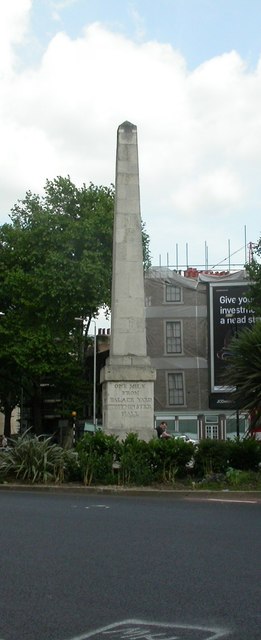
Approach St George's Circus today and the crossroads announces itself before you arrive: several roads converge on a stone obelisk ringed by two cabbage palms, its position at the southern end of Blackfriars Road unmistakably geometric amid the traffic. Look up Blackfriars Road and the line runs arrow-straight for almost a mile back to Blackfriars Bridge; look outward and London Road, Borough Road and Lambeth Road peel away toward the Borough, Lambeth and beyond. The circus itself is compact — barely wide enough to feel like a square — yet its scale was fixed by law: an 1812 Act required the junction's diameter to hold no less than 240 feet, and the concave Georgian frontages that curve around it still trace that original circle. Above it all, McLaren House's ten storeys mark the north west corner, while newer brick blocks close the north east side.
Name Origin
From marshland to monument
The name records two overlapping histories layered onto the same patch of ground. Long before any circus existed, this was common marshland on the south bank, agreed under a royal charter of 1377 and known simply as Southwark Fields, the Southwark Council conservation area appraisal notes. By the 15th century the marsh had acquired a more specific identity: it became known as St George's Fields, after the nearby church of St George the Martyr, whose dedication gave the whole tract its lasting parish association.
The "Circus" element arrived much later, and for a very practical reason. When Robert Mylne, surveyor to the Blackfriars Bridge Committee, was tasked with laying out new roads across St George's Fields following Acts of Parliament in 1719, 1751 and 1769, he planned the junction where several routes met in a distinctly Continental style — "in a Parisian manner", as the appraisal describes it — with a formal circus rather than a plain crossroads. The junction opened in 1771, the same year the Georgian obelisk was raised at its centre, and from that point the older field-name was folded into the new one: St George's Circus. The street therefore carries its dedication doubly, first to the medieval church and parish of St George the Martyr, and then to the specific piece of 1770s civic engineering that gave the name its current form.
History
Georgian planning and a well-travelled obelisk
St George's Circus belongs to one of London's earliest exercises in formal town planning south of the river. Southwark Council's conservation area appraisal describes it as part of a Georgian scheme providing "a formal termination to a broad, straight boulevard almost a mile long," linking the newly opened Blackfriars Bridge of 1769 to the points where highways diverged toward the Borough, Lambeth, Westminster and Newington. Robert Mylne, the bridge's surveyor and architect, was given charge of laying out St George's Fields under the Acts of Parliament passed in 1719, 1751 and 1769, and it was his design that produced the circus itself, completed in 1771 during the mayoralty of Brass Crosby — a junction Wikipedia records as London's first purpose-built traffic junction.
Three roads radiated outward at first — Lambeth Road, London Road and Borough Road — with St George's Road added a little later, and Waterloo Road cut through afterward once Waterloo Bridge opened, though that route was never part of Mylne's original formal layout. The buildings framing the circus were slower to arrive: the appraisal notes that the surrounding streets were not fully developed until around 1800, and it was only in 1812, under the St. George's Fields (Surrey) Improvement Act, that Parliament fixed the junction's future character, requiring new buildings to present concave fronts, a minimum circus diameter of 240 feet, and nothing built "inferior to the 3rd building rate" along Borough Road and the circus frontages.
The Victorian era brought disruption rather than refinement. The London, Chatham and Dover Railway drove viaducts through the area in the 1860s, bringing noise and smoke pollution close to the circus, and in 1898 the abortive City and Brixton Railway was authorised with a station planned for St George's Circus — a station that, like the wider scheme, was never built. The south side of the circus was long occupied by the School for the Indigent Blind, reconstructed and enlarged in the 1830s, before a 1901 brick building replaced it, itself concealing a subsurface depot for the London Underground's Bakerloo line.
Through all this the obelisk at the centre proved surprisingly mobile. It was removed in 1897 to make way for a clocktower marking Queen Victoria's diamond jubilee, and the obelisk itself was relocated in 1905 to what is now Geraldine Mary Harmsworth Park, in front of the Imperial War Museum. The clocktower fared worse: judged a nuisance to traffic, it was demolished in the 1930s, leaving the circus without its centrepiece for decades.
The obelisk that stands at St George's Circus today spent more than ninety years elsewhere — removed in 1897, moved to what is now Geraldine Mary Harmsworth Park in 1905, and not returned to its original spot until 1998.
Culture
A monument, a garden, and a reused pub
The circus's decorative history reaches beyond the planting bed. In 1900, a replica of the Mylne obelisk was placed at Brookwood Cemetery, marking the spot where human remains from the crypt of St George the Martyr, Southwark, were reburied the previous year — a quiet echo of the circus's own monument sent out to Surrey. Locally, the circus's Georgian fabric has itself become a point of civic pride: Southwark designated the area a conservation area in 2000, and by 2007 facade repairs had been completed across most of its surviving Georgian buildings. On the corner with London Road, the former Duke of Clarence public house, restored by London South Bank University in 2013 alongside the listed Victorian dwellings beside it, now serves as a business centre supporting the university's graduate entrepreneurs — a modest but deliberate reuse of a building that once served the circus's drinking trade.
People
Mylne, the mayor, and an inscription in stone
The circus's authorship is unusually well attributed for a London street junction. Robert Mylne (1733–1811), surveyor and architect of Blackfriars Bridge, was responsible for laying out St George's Fields under the Acts of Parliament of 1719, 1751 and 1769, and it was Mylne who chose to mark the junction with a formal circus rather than a simple crossroads. The obelisk he designed for the centre still carries its original 1771 inscription, reading "Erected in XI year of the reign of King George MDCCLXXI," and has been Grade II* listed since it was first added to the statutory list on 2 March 1950.
The circus's completion in 1771 fell during the mayoralty of Brass Crosby, whose tenure as Lord Mayor of the City of London provides the scheme's precise civic dateline, though the pack offers no further detail on his personal involvement beyond that association. Together, Mylne's design and Crosby's mayoral year fix St George's Circus firmly in the specific civic moment of the early 1770s, when Southwark's fields were being remade, bridge by bridge and road by road, into a formal extension of the growing capital.
"Erected in XI year of the reign of King George MDCCLXXI"Inscription on the St George's Circus obelisk, 1771
Recent Times
Return, recognition, and redevelopment
The twentieth century treated the circus's centrepiece unkindly before restoring it. After the clocktower's 1930s demolition, the obelisk itself did not return to St George's Circus until 1998, by then stripped of its original oil lamps, and its reinstatement was marked by new planting — two cabbage palms set into a semi-circular bed at its base. Two years later, on 23 October 2000, Southwark designated the whole junction a conservation area, formally recognising the surviving Georgian fabric around it.
Institutional building has continued alongside the heritage work. McLaren House, a ten-storey hall of residence for London South Bank University students, opened in 1996 on the site of a derelict 1890s building that had once housed the Royal Eye Hospital, and now holds around 600 students on the circus's north western side. In 2013, Barratt London bought existing office blocks on the north eastern side and announced plans for up to 400 new homes, a scheme realised as Blackfriars Circus, designed by Maccreanor Lavington; the development went on to win the RIBA National Award and RIBA London Award for 2021.
Today
Convergence, still
St George's Circus today reads as a conservation area built around a single, much-travelled monument. The Grade II* listed obelisk, restored to its original spot in 1998, still sits at the meeting point of Blackfriars Road, London Road, Borough Road, Lambeth Road and St George's Road, framed by the concave Georgian fronts the 1812 Improvement Act once mandated. Around it, the mix is now institutional and residential rather than purely commercial: McLaren House provides student accommodation to the north west, the restored Duke of Clarence building serves as a graduate business centre, and Blackfriars Circus adds thoroughly modern housing to the north east. The junction remains, as it always was, a place defined by convergence — several roads and nearly two and a half centuries of planning decisions meeting at one small, stubbornly persistent obelisk.
On the Map
St George's Circus Then & Now
Frequently Asked Questions
Why is it called St George's Circus?
The site was medieval marshland known as St George's Fields, named after the nearby church of St George the Martyr. When Robert Mylne completed a formal road junction here in 1771, the older field-name combined with the new "Circus" layout to give the street its current name.
What is St George's Circus known for?
It was London's first purpose-built traffic junction, completed in 1771 to a design by Robert Mylne, and is marked by a Grade II* listed obelisk that has travelled between locations before returning to its original spot in 1998. The surrounding Georgian streets form a designated conservation area.
Why did the obelisk leave St George's Circus and come back?
The obelisk was removed in 1897 to make way for a Queen Victoria diamond jubilee clocktower, then relocated in 1905 to what is now Geraldine Mary Harmsworth Park. After the clocktower was demolished in the 1930s as a traffic nuisance, the obelisk was finally returned to St George's Circus in 1998.