Time Walk
A square of four faces


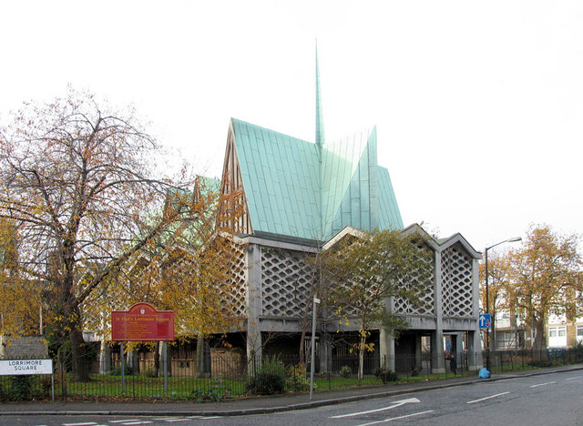
Arrive from Kennington, some 500 metres to the north-west, and Lorrimore Square announces itself quietly — a 1.5-acre garden space tucked into south-west Southwark, as Wikipedia's account of the square describes it. Walk its perimeter and the square reveals itself in quarters: a church with an attached drop-in centre on one side, a small enclosed garden with no paths running through it, a public playground and gardens for the neighbourhood, and a basketball and netball pitch where the square's newer life plays out. One flank still shows off four storeys of classical terracing behind black railings, basement gardens sunk below street level; the other two sides are late-twentieth-century apartment rows, built to roughly matching height. It is a square assembled in layers, each one legible if you look for it.
Name Origin
From Lattam-more to Lorrimore
The name has nothing to do with lorrimers or leather-workers, however it might sound. Wikipedia's account of the square traces it to a corruption of "Lower Moor" — a name that surfaces on a 1681 map of Walworth drawn up for the Dean and Chapter of Canterbury Cathedral, where a wider tract of common land appears labelled "Lattam-more". Over the following century and a half, that name shifted in the mouth from Lattam-more toward Lorrimore, eventually settling onto the square and the surrounding streets — Lorrimore Road among them — that were built nearby.
It is worth noting what the Survey of London's account of the manor of Walworth adds to this picture: the square itself was not built on the common at all, but on a close of land lying to its south-west. The name, in other words, migrated with the memory of the moor rather than marking its actual footprint — a common enough pattern in London's naming history, where a vanished landscape feature leaves its label on the streets that replace it. The Dean and Chapter of Canterbury Cathedral's long-standing interest in this ground reappears later in the story, when it was the Dean and Chapter who granted the land for the square's parish church.
"Lattam-more"1681 map of Walworth, made for the Dean and Chapter of Canterbury Cathedral
History
Church, close and common
The documented history of Lorrimore Square begins in earnest in 1856, when the Survey of London's account of the manor of Walworth and parish of St Mary, Newington records that St. Paul's Church was completed and consecrated on ground given by the Dean and Chapter of Canterbury. The architect was Henry Jarvis, working in Victorian Gothic style, a commission also noted in the Survey's separate account of the Trinity House Estate. Around the same date, the ground surrounding the new church was let out in several lots to three builders — John Marsland of Walworth Road, John Lucas Allen of Finsbury Square, and John Abbott of Manor Road South, Newington — and the houses of the square itself, the Survey notes, were completed at about the same time as the church, giving the whole development a coherent, single-generation character.
The square's ecclesiastical geography shifted again in 1874, when the district served by St. Paul's was carved out of the existing parish to help form the new parish of St. Agnes, as the Survey of London's account of St Agnes Church records. Nearby, on the south side of Lorrimore Road, a second place of worship arrived in 1914: St. Wilfred's Roman Catholic Church, designed by Frederick Arthur Walters, a substantial red brick building distinguished by a 60-foot battlemented tower topped with a short spire.
The square's Victorian fabric did not survive the twentieth century intact. Incendiary bombs fell on Lorrimore Square during the London Blitz, and the first church on the site burned down, leaving only its steeple standing, Wikipedia's account records. The congregation waited nearly two decades for a replacement: the current church was built in 1959–60, a piece of post-war reconstruction that still anchors one corner of the square today.
Culture
A square divided into uses
Lorrimore Square's present character owes much to how deliberately it is divided. Wikipedia's account describes four distinct sections functioning almost as separate neighbourhood facilities: the church, now paired with an integrated drop-in centre serving the local community; a small enclosed garden kept free of paths, a quieter contemplative pocket; a public playground and gardens open for general use; and a basketball and netball pitch giving the square an active, recreational edge that few Georgian or Victorian garden squares retain. This is not a square preserved as ornamental green space alone — it works, in its various quarters, as a place of worship, welfare, play and sport all within the same 1.5 acres.
The square's eastern flank, Chapter Road, sits within the Sutherland Square Conservation Area — a nod to the classical terraces still standing behind their black railings, even as the rest of the square was rebuilt after the war.
That conservation status marks a line of continuity back to the square's original Victorian layout, protecting the four-storey terraced housing with its basement gardens even as the surrounding blocks were replaced by later apartment building.
People
The builders behind the square
Lorrimore Square owes its architectural character to a small handful of named figures recorded in the Survey of London. Henry Jarvis designed St. Paul's Church in 1856 in Victorian Gothic style, a building that stood at the square's centre for over eighty years before the Blitz claimed all but its steeple. Frederick Arthur Walters, working just south on Lorrimore Road, gave the parish its second major place of worship in 1914 with St. Wilfred's Roman Catholic Church, a red brick structure whose battlemented tower and short spire were noted as a substantial addition to the local skyline.
The domestic terraces around the square were the work of three builders operating in the same mid-1850s window as Jarvis's church: John Marsland of Walworth Road, John Lucas Allen of Finsbury Square, and John Abbott of Manor Road South, Newington, each taking on separate lots of the ground let out around the new church. Their houses, the Survey of London notes, were finished at roughly the same time as St. Paul's itself, which explains the visual coherence still visible in the surviving classical terrace on one side of the square today — a single building campaign, spread across three hands but completed within a very short span.
Recent Times
Rebuilding around the bomb site
The square's recent history is largely the story of what replaced what the Blitz took away. After the original St. Paul's burned during the Blitz, leaving only its steeple, the site stood as a scar in the square for close to two decades before the new church was raised in 1959–60. That rebuilding coincided with, or was followed by, a wider renewal of the housing stock: two of the square's three sides today are late-twentieth-century apartment rows, built to a similar height to one another, replacing whatever earlier fabric had stood or been damaged there.
Only one side kept its Victorian identity intact — the four-storey classical terrace behind black railings, with basement gardens still sunk below pavement level. That survival is now formally protected: the eastern side of the square, Chapter Road, falls within the Sutherland Square Conservation Area, a status that has presumably shaped what alterations have been permitted there since. The square today reads, as a result, as a patchwork of three distinct building periods sitting around a shared green centre.
Today
A working neighbourhood square
Lorrimore Square today sits quietly within the SE17 postcode district, a short walk from Kennington tube station but with a character distinctly its own. Its four functional quarters — church and drop-in centre, enclosed garden, public playground, and sports pitch — mean it serves a wider range of daily needs than a purely ornamental square would. The mix of surviving Victorian terrace and later apartment blocks around its edges gives it a visibly layered streetscape, while the conservation area designation on its eastern side ensures that at least one chapter of its Victorian past remains legible for anyone walking its perimeter.
On the Map
Lorrimore Square Then & Now
Frequently Asked Questions
Why is it called Lorrimore Square?
The name is a corruption of "Lower Moor". Wikipedia's account traces it to a 1681 map of Walworth, made for the Dean and Chapter of Canterbury Cathedral, which labels a wider common as "Lattam-more" — a name that gradually shifted into Lorrimore and attached itself to the square built nearby.
What is Lorrimore Square known for?
It's known for its division into four distinct uses within a single 1.5-acre space: a church with an integrated drop-in centre, an enclosed garden, a public playground, and a basketball and netball pitch, alongside a surviving Victorian terrace protected within the Sutherland Square Conservation Area.
Was Lorrimore Square damaged in the Blitz?
Yes. Incendiary bombs hit the square during the London Blitz, and the original St. Paul's Church burned down entirely except for its steeple, Wikipedia's account records. A replacement church was not built until 1959–60.