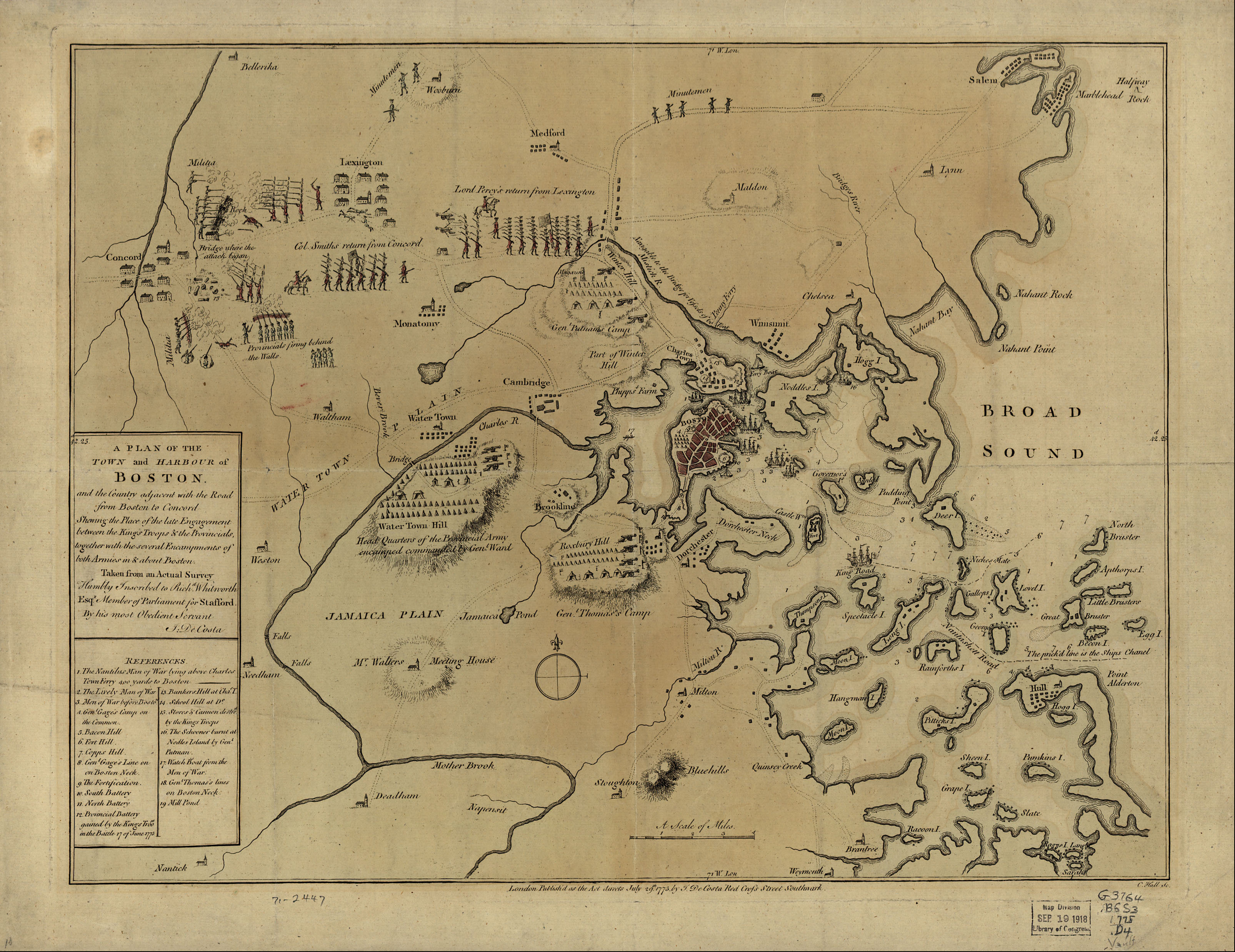
Bermondsey preserved its rural character well into the seventeenth century. The land that would become Fort Road sat south of Jamaica Road on ground that had been market garden and open field, part of the ancient parish of St Mary Magdalene. Parliament’s 1642 decision to fortify London transformed this open ground overnight: earthen ramparts with bastions were thrown up along the southern roads with remarkable speed, guarding every route a Royalist army might use to approach the capital from the south.
1642–3
Parliamentary Fort Built
Parliament orders earthwork fortifications around London’s southern approaches; a fort is constructed by Kent Street, giving the future road its name.
c. 1787
Open Land, Market Gardens
An 1787 map shows the area still largely undeveloped, with market gardens and open ground surrounding the future line of the street.
c. 1846
Urban Development Begins
Bermondsey’s suburban growth accelerates. The built environment becomes as much industrial as residential, with rope walks and tan yards giving way to terraced streets.
c. 1868
Southwark Park Opens
London’s first municipal park opens nearby, providing relief from the densely packed industrial housing that now surrounded Fort Road.
c. 1880s–90s
Victorian Residential Build-Out
The street assumes its present form with a run of terraced houses. Historical mapping shows Fort Road as a pocket of better-than-average housing in the industrial landscape north-east of Bricklayer’s Arms.
late 19th c.
Primitive Methodist Chapel
A Primitive Methodist chapel is established on Fort Road, recorded in the Victoria County History of Surrey among Bermondsey’s growing network of Nonconformist places of worship.
Did You Know?
The pub that once stood at the corner of Grange Road near Fort Road was known as the Royal Fort—later renamed Bugles—preserving the local memory of the Civil War earthwork in its name long after the ramparts themselves had vanished beneath Victorian streets.
After the Civil War the earthworks were left to decay, and the land gradually reverted to agricultural use. Bermondsey’s explosion of industry and housing in the early Victorian period—driven by tanning, rope-making, and riverside trade—eventually buried the last traces of the rampart. The London Picture Archive records a view looking north towards Fort Road from the Old Rope Walk, between houses numbered 68 and 70, a reminder that rope-making was once a defining industry in the immediate neighbourhood. By 1900, as documented by British History Online, Bermondsey’s population had reached over 81,000—almost entirely working class—and the street had found its permanent shape as part of a self-contained residential and industrial quarter.
Excavations across Bermondsey over the decades have shed light on earlier layers beneath its Victorian streetscape. As MOLA (Museum of London Archaeology) has demonstrated through fieldwork in the wider parish, the ground in this part of south London is a palimpsest of reclaimed marsh, medieval occupation, and post-medieval industrial activity—layers that underlie Fort Road’s terraces today.