Lambeth London England About Methodology
Lambeth · SW2 · Clapham

Brixton Hill Place

A Saxon boundary stone gave its name to an ancient Roman road — and that road, in turn, gave its name to this short private turning in Clapham.

Name Meaning
Stone of Beohtsige
First Recorded
1062 (Brixiges Stan)
Borough
Lambeth
Character
Mixed residential & commercial
Last Updated
Time Walk

Where the Roman Road Meets the Side Street

Brixton Hill Place opens off the A23 — one of south London’s oldest and busiest corridors — as a short private road in the Clapham neighbourhood of Lambeth. It is a mixed commercial and residential street. The road is approximately 77 metres long and has seven properties. Step out of it onto the main road and you are standing on a route that has carried travellers, drovers, and trams south from London since Roman times.

2007
Brixton Hill, SW2
Brixton Hill, SW2
Wikimedia Commons · CC BY-SA 2.0
2018
Brixton Hill, A23
Brixton Hill, A23
Wikimedia Commons · CC BY-SA 2.0
2020
132-136 Brixton Hill
Wikimedia Commons · CC BY-SA 2.0
Today
Rush Common — near Brixton Hill Place
Geograph · CC BY-SA 2.0

The place carries its history in layers: beneath the Victorian terraces lies the memory of Rush Common, market gardens, a prison, and a windmill. The name overhead on the street sign points back much further still — to a Saxon lord and the stone he planted to mark the edge of his hundred.

✦   ✦   ✦
Name Origin

Beohtsige’s Stone and the Bristow Causeway

That Saxon lord’s stone is where the name chain begins. The name Brixton goes back to 1062, when it appeared as “Brixiges Stan” in an Anglo-Saxon charter, and then as “Brixiestan” in the Domesday Book of 1086. It comes from Old English and translates as “stone of a man called Beorhtsige.” As documented in the Survey of London on British History Online, the northern section of the road now called Brixton Hill was formerly called Brixton Causeway, and the name Brixton, with many variations, dates from at least the 11th century.

Manning and Bray suggested that the Causeway derived its name from the boundary stone, though they also quoted another explanation: that in the 14th century Sir John de Burstow repaired this piece of road with stone, and it was subsequently known as Burstow or Bristow Causeway. Prior to the late 19th century the road was known as Brixton (or Bristow) Causeway. The suffix “Place” is a standard Victorian convention for a short side street or enclosed yard off a principal road; the specific date on which this turning acquired its formal name is not recorded in available sources.

How the name evolved
1062 Brixiges Stan
1086 Brixiestan
c. 1530 Bristowe Cawsey
pre-1880s Brixton Causeway
present Brixton Hill Place
✦   ✦   ✦
History

Common Land, Correction House, and Cable Cars

The road follows the line of a Roman road, the London to Brighton Way, which diverges from Stane Street near Kennington and led south from Londinium to a port on the south coast. For centuries, the lane we now call Brixton Hill ran through marsh and farmland. The earliest known reference to the causeway is contained in a will of 1530, when Hugh Acton left £20 for making and repairing the highway from Streatham Church to the foot of “Bristowe Cawsey.”

Key Dates
1062
Brixiges Stan
First recorded mention of the Saxon boundary stone in an Anglo-Saxon charter, giving the area its name.
1530
Bristowe Cawsey
Hugh Acton’s will leaves £20 to repair the highway to the foot of “Bristowe Cawsey” — the earliest written reference to the causeway.
1806
Rush Common Enclosed
The Rush Common Enclosure Act shapes all future development: no buildings within 150 feet of the road on the eastern side.
1816
Windmill & Vauxhall Bridge
John Ashby builds his windmill half-way up Brixton Hill. Vauxhall Bridge opens, triggering suburban growth along the A23 corridor.
1819
House of Correction
Brixton House of Correction (later Brixton Prison) is built on five acres just up the hill, becoming a defining institution of the neighbourhood.
1891
Cable Trams
Brixton Hill becomes London’s first cable-tram route south of the river, with steam-powered winding gear hauling cars up the gradient.
1904
Electric Trams
Cable haulage is replaced by conventional electric trams, which serve Brixton Hill until the 1950s.
Did You Know?

A will dated 1530 records a bequest of £20 to repair the highway to the foot of “Bristowe Cawsey” — making Brixton Causeway one of the earliest road-repair bequests documented in Lambeth’s history.

With the enclosing of the Manor of Lambeth — owned by the Archbishop of Canterbury — in 1806 and the opening of Vauxhall Bridge in 1816, terraced houses and detached villas started to line the main roads. The Survey of London records, as published on British History Online, that houses on Brixton Hill were erected between 1816 and 1824, with some described as empty as late as 1824 and one inscribed as erected in 1820.

Soon after Brixton Windmill was built, Brixton House of Correction — more commonly known as Brixton Prison — was built in 1819–20 on five acres of land purchased from the manor. The prison moved to Wandsworth in 1851 and the land was sold, only to be bought back in 1853 for a Women’s Prison. That experiment closed in 1869, and it was used as a military prison from 1882 to 1898, before becoming London’s male remand prison in 1902.

c. 1900
Brixton Windmill, a five-storey tower mill, in Windmill Gardens just off Brixton Hill
Brixton Windmill (1816) — the Grade II* listed tower mill built by John Ashby, yards from Brixton Hill Place.
Wikimedia Commons · Public domain
1820s
Stucco-fronted three-storey Regency terrace at 139–145 Brixton Hill, dated to the 1820s
Brixton Hill Terrace (Nos 139–145), erected c. 1820 — Regency stucco terraces of the type that defined the corridor.
Wikimedia Commons · Public domain
c. 1892
Cable-tram era image
not available on
Wikimedia Commons
Brixton Hill carried London’s only southern cable tram from 1891, with winding gear at the Streatham Hill depot.
No free image available
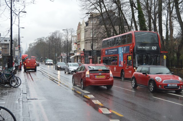
present
Modern street view of Brixton Hill looking south, with buses and terraces
Brixton Hill today — the A23 corridor unchanged in alignment since Roman times.
Geograph / Wikimedia Commons · CC BY-SA 2.0
✦   ✦   ✦
Culture

The Mill That Outlasted Everything Else

Ashby’s Mill, one of the few surviving windmills in London, was built in 1816, just off Brixton Hill. Wind power was used to grind flour until 1862, by which time the area had become too built up for the windmill to operate efficiently, and milling was moved to Mitcham. The mill was listed as Grade II* in 1951. Historic England’s listing records confirm the windmill as one of Lambeth’s most significant surviving pre-Victorian industrial structures — a rare physical trace of the agricultural Brixton that existed before the suburb arrived.

Sails Above the Suburb
Brixton Windmill — Grade II* Listed, 1816

Built by John Ashby and in continuous use until 1862, Brixton Windmill stands within Windmill Gardens minutes from Brixton Hill Place. As confirmed by Historic England’s listing, it is one of the best-preserved tower mills in Greater London, and one of very few to have operated within three miles of central London.

From 1891 until the 1950s, Brixton Hill was served by a regular London tram service, cable-drawn until 1904 when replaced by a conventional electric tram. The tram depot at Streatham Hill, opposite Telford Avenue, housed the tram cars, horses, and the steam-powered winding gear. Another surviving tram shed, near the junction of Brixton Hill with Christchurch Road, was designed by London County Council Tramways’ architect G. Topham Forest and had a capacity of 30 trams. That shed still stands.

✦   ✦   ✦
People

Booksellers, Millers, and a Saxon Whose Name Endures

The most enduring personal name attached to this address is the oldest: Beohtsige, the Saxon lord whose boundary stone is preserved — in corrupted form — in every sign along the A23 from Brixton to Streatham Hill. No portrait exists, no dates are recorded; only the stone, and then the road, carried his name forward through a thousand years of London history.

Edward Petherick, an Australian bookseller and bibliophile, lived at ‘Yarra Yarra,’ 30 Brixton Hill, maintaining a library that was particularly extensive as regards Australia. The miller John Ashby, who built the windmill in 1816 and whose family operated it for its entire working life, is the neighbourhood’s most tangible human presence. By the 1840s, despite owning a flourishing milling business, Ashby agreed with builder John Muggeridge to let the eastern half of his land for building, and seven houses fronting Cornwall Road were erected. Both men left their mark in brick and timber rather than in street names.

✦   ✦   ✦
Recent Times

Windrush, Redevelopment, and the Changing Hill

The Brixton area was bombed during the Second World War, contributing to a severe housing crisis, which in turn led to slum clearances and the building of council housing. In the 1940s and 1950s, many immigrants — particularly from the West Indies and Ireland — settled in Brixton, with it becoming the “unofficial reception centre” for those arriving in London. The streets around Brixton Hill Place were remade by those arrivals, their culture and community reshaping the neighbourhood beyond recognition from its Victorian self.

Archaeological investigations carried out by MOLA (Museum of London Archaeology) across the wider Lambeth area have traced the Roman road alignment that underlies Brixton Hill, confirming that the A23 corridor has been in continuous use as a major route since at least the 1st century AD. The physical street of Brixton Hill Place, as a private road off that corridor, has not been the subject of a dedicated excavation report.

“The name Brixton dates from at least the 11th century — its derivation suggested as ‘at the stone of Beohtsige.’”
Survey of London, Vol. 26 — Lambeth: Southern Area (1956), via British History Online
✦   ✦   ✦
Today

Private Road, Public History

Brixton Hill Place is today a mixed commercial and residential street, and a private road not maintained by the council. Its seven properties sit within one of London’s most culturally layered postcodes, the SW2 corridor that runs from Brixton town centre up toward Streatham Hill. The neighbourhood of Clapham presses in from the west; the A23 carries its continuous traffic outside.

Green space is within easy reach. The nature highlights below reflect the parks that frame this corner of Clapham and Lambeth, from the common land stipulations of 1806 to the Victorian-era open spaces that survived the suburb’s advance.

10 min walk
Clapham Common
220 acres of common land to the north-west; bandstand, ponds, and ancient lime avenues dating to the 18th century.
5 min walk
Windmill Gardens
The small public garden surrounding Brixton Windmill; protected open space under the 1806 Act.
15 min walk
Brockwell Park
125 acres of hilltop parkland with panoramic views across south London; includes the Grade II listed Lido.
12 min walk
Rush Common
The tree-lined open strips on the eastern side of Brixton Hill — a direct remnant of the 1806 enclosure that shaped the whole neighbourhood.
✦   ✦   ✦
On the Map

Brixton Hill Place Then & Now

National Library of Scotland — Ordnance Survey 6-inch, c. 1888. Hosted by MapTiler. Modern: © OpenStreetMap contributors.

✦   ✦   ✦

Frequently Asked Questions

Why is it called Brixton Hill Place?
Brixton Hill Place takes its name from Brixton Hill, the section of the A23 on which it stands. Brixton most likely derives from the Old English Beohtsige’s stan — “stone of Beohtsige” — a Saxon boundary marker recorded as “Brixiges Stan” in 1062. The name passed from the stone to the causeway, from the causeway to the hill, and from the hill to this short private turning. The suffix “Place” was a standard Victorian convention for a yard or side street off a principal thoroughfare.
When did suburban development begin along Brixton Hill?
Development began in earnest after two events: the Rush Common Enclosure Act of 1806, which set the building line back 150 feet from the road on the eastern side, and the opening of Vauxhall Bridge in 1816, which made south London newly accessible from the City. The Survey of London records houses on Brixton Hill being erected between 1816 and 1824, with some still empty as late as 1824. Before that, the hill was agricultural land — market gardens and farmland bordered by marsh.
What is Brixton Hill Place known for?
Brixton Hill Place is a short private road off one of south London’s most historically layered thoroughfares. The A23 beneath it follows the alignment of a Roman road; the causeway above it carried a pioneering cable tram from 1891; and the windmill John Ashby built in 1816 — Grade II* listed — still stands in Windmill Gardens minutes away. The surrounding Clapham neighbourhood was shaped by the 1806 enclosure of Rush Common, a piece of legislation whose consequences are still visible in the tree-lined verges along the hill today.