Hackney London England About Methodology
Hackney · E8 · Stoke Newington

Allen Road

Named after a Quaker chemist who campaigned against slavery, this Stoke Newington terrace once sustained four pubs and a local printing press.

Name Meaning
Allen family
First Recorded
c. 1863
Borough
Hackney
Character
Victorian terrace
Last Updated
Time Walk

Four Pubs and a Scrap Yard

Allen Road runs through Stoke Newington as a compact Victorian terrace of stock-brick houses, most of which are now split into flats. The street connects Shakspeare Walk to Nevill Road, sitting within the Clissold ward—a patch of north Hackney defined by its leafy streets, dissenting history, and the great green lung of Clissold Park a few minutes’ walk to the north-west.

2015
Allen Road, Stoke Newington
Wikimedia Commons · CC BY-SA 2.0
2015
Allen Road, Stoke Newington
Wikimedia Commons · CC BY-SA 2.0
2017
The entrance to Hackney Marshes
Wikimedia Commons · CC BY-SA 2.0
Today
The Shakespeare, Stoke Newington — near Allen Road
Geograph · CC BY-SA 2.0

The Shakespeare pub is the last survivor of what was once a four-pub street, an echo of a time when Allen Road hummed with small commerce, friendly society meetings, and working-class street life. That density of local institutions, and the name above them all, points back to a family whose mark on Stoke Newington ran far deeper than a street sign.

✦   ✦   ✦
Name Origin

The Quaker Chemist of Stoke Newington

The Allen name in Stoke Newington is most closely tied to William Allen (1770–1843), a Quaker chemist, philanthropist and anti-slavery campaigner who, as recorded by British History Online, settled in the parish in 1795 and became one of its most prominent residents. Allen ran a chemical works in Plough Court, Lombard Street, but Stoke Newington was his home, his schooling enterprise and his spiritual base. He was a friend of royalty, a collaborator of the Lancasterian educational movement, and a presence at the anti-slavery meetings that gathered regularly in the neighbourhood.

The Allen name became formally attached to local properties through what British History Online identifies as “Allen’s flats” on Bethune Road and Manor Road, built nearby in 1873–5 by Matthew Allen, a builder of the same Stoke Newington Quaker family. The road itself is believed to take its name from this same Allen connection—a family whose philanthropic and commercial footprint across the neighbourhood made their name a natural one for its expanding Victorian streets.

How the name evolved
c. 1863 Allen Road
present Allen Road
✦   ✦   ✦
History

Terraces, Taverns and Friendly Societies

Allen Road emerged as part of the great Victorian building wave that, as British History Online documents, transformed Stoke Newington between 1870 and 1914 from a semi-rural retreat for City merchants into a densely packed working-class suburb. Land that had sold for £100 an acre in the early part of the century was reaching £2,200 by 1870. Builders crammed terraced houses wherever they could, and Allen Road was typical of that era: modest stock-brick two-storey homes intended for artisans, clerks and shopkeepers.

Key Dates
1795
Allen arrives
William Allen (1770–1843), Quaker chemist and anti-slavery campaigner, settles in Stoke Newington, beginning the Allen family’s long association with the parish.
c. 1863
Road established
Allen Road appears in records; the Hand and Heart United friendly society moves its meetings to a pub on the road, remaining until 1868.
1873–5
Allen’s Flats built
Matthew Allen, builder of the local Quaker family, constructs middle-class flats on Bethune and Manor roads nearby, cementing the Allen name on the neighbourhood.
1907
Commercial peak
The Hackney and Kingsland Gazette advertises a double-fronted general shop at No. 33 Allen Road, showing the street’s mixed residential and trading character at its Victorian height.
1921
Census snapshot
577 people are recorded as resident on Allen Road. The majority of householders are middle-class tradespeople and artisans, though overcrowding is already evident in some properties.
c. 1939–45
Press in the road
The North London Observer—later the Stoke Newington and Hackney Observer—is printed in Allen Road during this period, making it briefly a minor centre of local journalism.
1976
Rehabilitation
Hackney Council’s Shakspeare Walk action area designates Allen Road for restoration; shops and houses are refurbished rather than demolished.
Did You Know?

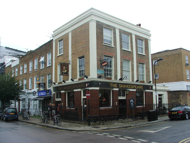
Allen Road once had four pubs serving its residents and the surrounding streets. By the early 21st century, only one—the Shakespeare—had survived the slow retreat of the Victorian corner pub from residential Stoke Newington.

By the 1860s, the road was already socially active. As noted in the Victoria County History via British History Online, the Hand and Heart United friendly society—a working-class mutual aid organisation—moved its meetings to a pub in Allen Road in 1863, remaining there until 1868. Four pubs in all served the street at its Victorian peak, providing meeting rooms, entertainment and community functions that no other institution yet offered working people.

The mid-20th century brought decline and renewal in cycles. Stoke Newington was sharply divided by the 1980s between Victorian housing and post-war council blocks; Allen Road belonged to the Victorian portion, and its fabric was preserved by Hackney Council’s rehabilitation programme rather than swept away. Number 33—which had been a general shop by 1907 and a scrap-metal yard by the 1980s—was eventually converted to residential use, filling in the last large yard on the street.

✦   ✦   ✦
Culture

Ink, Ale and Mutual Aid

Allen Road carried a local newspaper press in its buildings during and after the Second World War. The North London Observer, founded in 1939, was printed in Manor Road and later in Allen Road; it eventually became the Stoke Newington and Hackney Observer, running until 1971. For a short stretch, this unassuming residential terrace was a place where local news was physically made—typeset, inked and distributed from doors that otherwise fronted ordinary Victorian homes.

Working-Class Institution
The Hand and Heart United Friendly Society

From 1863 to 1868, a pub on Allen Road served as the meeting place of the Hand and Heart United friendly society, a working-class mutual aid organisation. Friendly societies were the welfare state before the welfare state: members paid in weekly, and drew out during illness, unemployment or bereavement. That Allen Road hosted one is a precise record of who lived here and what they needed.

The four pubs that once served Allen Road were not incidental—they were the street’s community infrastructure. In the 19th century, as the Victoria County History notes, pubs across Stoke Newington multiplied rapidly as the neighbourhood urbanised, serving as meeting rooms, postal collection points and social clubs for residents who had no other gathering place. The loss of three of Allen Road’s four pubs across the 20th century is a condensed history of how that infrastructure dissolved.

✦   ✦   ✦
People

The Chemist, the Builder and the Census

William Allen (1770–1843) never lived on Allen Road itself—the street post-dates him—but his presence in Stoke Newington from 1795 onwards was transformative enough to leave his family name on the neighbourhood’s Victorian fabric. He ran a school on his Lordship Road estate, attended anti-slavery meetings with William Wilberforce, and was, according to British History Online, a “friend of princes” who brought national renown to this small north London parish.

Matthew Allen—builder, Stoke Newington Quaker and likely a member of the same extended family—built the “Allen flats” on nearby Bethune and Manor roads in 1873–5. These three-storeyed blocks in grey brick and painted stucco were described by contemporary architects as admirable. They survive, and with Allen Road they form a small topographic cluster that preserves a Quaker family’s name across the neighbourhood’s streets and buildings.

✦   ✦   ✦
Recent Times

Rehabilitation and the Last Yard

In 1976, Hackney Council designated the Shakspeare Walk area—including Allen Road—a rehabilitation action area. Rather than demolishing the Victorian fabric as had been done elsewhere in the borough, the council restored shops and houses in place. The decision preserved Allen Road’s terrace streetscape at a moment when many comparable streets elsewhere in Hackney were being replaced by council blocks.

By the mid-1980s, the only business operating from a large yard was a scrap-metal dealer at No. 33—the one property on the street with a drive-in yard to the side. That yard has since been filled with residential development. The trajectory is familiar across inner north London: commerce retreating, residential use expanding, and former commercial plots quietly absorbed into the housing stock.

✦   ✦   ✦
Today

Victorian Brick in a Leafy Ward

Allen Road remains a mixed residential and commercial street—its Victorian terraces now predominantly converted to flats—in the Clissold ward of Hackney. The Shakespeare pub stands as the one remaining Victorian licence on the road. Grasmere Primary School is yards away, and Stoke Newington School and Sixth Form is within easy walking distance, making this a family-anchored patch despite its inner-city density.

The green spaces around Allen Road are among the best in inner north London. Clissold Park, with its lakes and walled garden, sits minutes to the north-west. Abney Park Cemetery—one of London’s great Victorian garden cemeteries—is close to the north-east. Both are within the walk that any Allen Road resident takes as a matter of daily routine.

8 min walk
Clissold Park
54 acres of parkland with two lakes, a deer enclosure and a Victorian mansion. One of north London’s finest public parks.
10 min walk
Abney Park Cemetery
A Grade I listed Victorian garden cemetery and local nature reserve, with ancient woodland and Grade II* listed chapel ruins.
12 min walk
Stoke Newington Common
A small, open common with a community feel; historically Cockhangar Green, now one of the neighbourhood’s informal gathering points.
15 min walk
Butterfield Green
A pocket park created in the late 1970s–early 1980s from cleared housing stock, now a valued local green space.
✦   ✦   ✦
On the Map

Allen Road Then & Now

National Library of Scotland — Ordnance Survey 6-inch, c. 1888. Hosted by MapTiler. Modern: © OpenStreetMap contributors.

✦   ✦   ✦

Frequently Asked Questions

Why is it called Allen Road?
Allen Road in Stoke Newington most likely takes its name from the Allen family, prominent Quakers who were deeply embedded in the neighbourhood from the late 18th century. The most notable member was William Allen (1770–1843), a chemist, philanthropist and anti-slavery campaigner who lived in Stoke Newington from 1795. British History Online records an “Allen flats” development on nearby Bethune Road and Manor Road, confirming the Allen name was formally attached to local properties in the Victorian era.
How many pubs did Allen Road once have?
Allen Road once had four pubs serving its residents and surrounding streets. In the 19th century, when a pub was the main place to socialise and there were no alternative entertainments such as the cinema or television, four pubs was considered the right number for a street of this size and its immediate neighbourhood. Today, only one—the Shakespeare—survives.
What is Allen Road known for?
Allen Road in Stoke Newington is a mixed Victorian terrace best known today for its surviving Shakespeare pub and its well-preserved stock-brick houses, many now converted to flats. Historically it was a lively street with four pubs, a range of small businesses, and a working-class friendly society that met here in the 1860s. It was also home to a printing press for the North London Observer during the mid-20th century, and its shops and houses were restored as part of a Hackney Council rehabilitation programme in 1976.